BCSC Safe Routes to School Plan
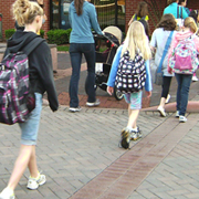 The Bartholomew Consolidated School Corporation (BCSC) Safe Routes to School Plan was completed in 2012 through the efforts of the Bartholomew County Safe Routes to School Committee. Along with the Planning Department, the committee is composed of representatives from the Engineering, Police and Parks Departments; the Metropolitan Planning Organization; Healthy Communities; the BCSC Transportation Department; and principals and teachers from each school.
With grant money received from the Indiana Department of Transportation (INDOT), the Bartholomew County Safe Routes to School Committee worked with consultants, Alta Planning & Design and Burgess & Niple, to create the BCSC Safe Routes to School Plan for nine schools (Lincoln CSA, Parkside, Richards, Schmitt, Smith, Southside, & Taylorsville Elementary and Central & Northside Middle School). The plan identifies areas around each school that need intersection improvements, sidewalk repair, bicycle parking, enhanced lighting, or traffic control and provides recommendations for improvements. The plan also includes various educational programs and incentives to support walking and biking to school.
The Planning Department managed the grant administration and contract and the day-to-day efforts of the consultants. The plan has been adopted by the BCSC School Board and endorsed by the City Council and the County Commissioners.
BCSC Safe Routes to School Plan (PDF)
For information on the National Center for Safe Routes to School go to www.saferoutesinfo.org.
Camp Atterbury/Muscatatuck Joint Land Use Study
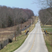 The Joint Land Use Study was completed in 2009 and is the result of a cooperative venture between the Indiana National Guard; Bartholomew, Brown, Jennings, and Johnson Counties; the City of Columbus; the Towns of Edinburgh and Prince’s Lakes; and the Cordry-Sweetwater Conservancy. The project was funded by the U.S. Department of Defense, Office of Economic Adjustment . The need for the study was generated by the rapid growth and substantial increase in the use of Camp Atterbury and the Muscatatuck Urban Training Center by the Indiana National Guard and other branches of the military.
The study compared the long-term facility and operational plans of the military installations with the land use patterns, transportation infrastructure, and future plans of the surrounding communities. The intent was to identify and manage any incompatibilities. Common issues around military facilities include hazards to and from military aircraft and the noise created by military training exercises.
The objectives of the JLUS were to (1) encourage cooperative land use planning between military installations and the surrounding communities; (2) seek ways to reduce the operational impacts of military installations on adjacent land; (3) reduce potential incompatibilities between the military installation and surrounding communities while still accommodating new growth and economic development; and (4) protect the general public’s health, safety, and welfare without compromising the operational missions of the installation.
Camp Atterbury / Muscatatuck Joint Land Use Study (JLUS) (PDF)