Public Urban Forest Management Plan and Street Tree Inventory
The City recently contracted the services of the Davey Resource Group to 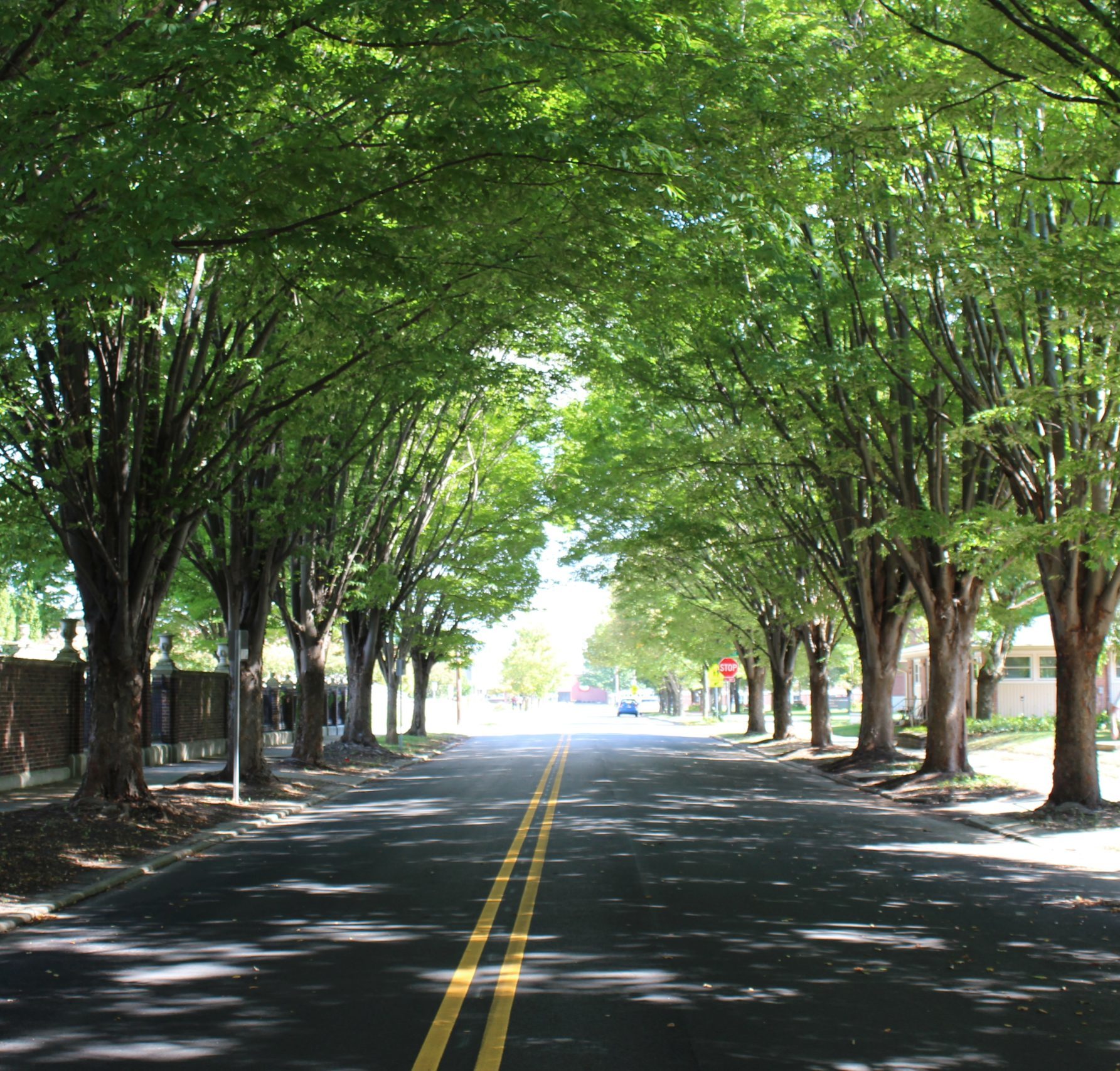 perform a partial tree inventory for trees in the right-of-way (commonly referred to as street trees) for the area known as the “Big Block” (generally from 25th Street south to 2nd Street and from Jackson Street east to Central Avenue). A total of 4,009 sites were recorded: 2,984 street trees, 180 stumps, and 845 planting sites. The data collection included, location, tree species, size, and condition. With that data, Davey Resource Group was also contracted to provide an analysis of those trees and to create an Urban Forest Management Plan for public street trees.
A management plan is intended to help develop a prioritized maintenance and proactive inspection and pruning cycles based on the inventory data to improve tree health. Other elements of a street tree management plan include developing a tree planting program to mitigate necessary removals, increase canopy cover, to develop a public outreach program to understand the benefits of urban trees, and to explore the many ways the community can help support the City’s overall urban tree canopy.
The Management Plan and Street Tree Inventory was initiated by the Tree Canopy Partners which is a group made up of Columbus citizens, the Columbus Planning Department, the Department of Public Works and the Columbus Parks and Recreation Department. The Plan was funded by a 50/50 matching grant from the Indiana Department of Natural Resources, Division of Forestry, Community and Urban Forestry program (IDNR CUF) in cooperation with U.S. Forest Service (USFS) through its Urban and Community Forestry (U&CF) Grant Program.
Public Urban Forest Management Plan
City of Columbus Neighborhood Commercial Access and Design Study
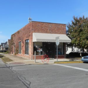 Neighborhood commercial centers are small-scale commercial developments located within or near the boundary of residential neighborhoods. These centers are intended to provide value to surrounding residential areas by offering necessity goods, services, and amenities within walking distance of homes. However, commercial uses can sometimes be bothersome to nearby residents. The Neighborhood Commercial Access and Design Study was initiated by the Planning Department to explore the benefits of neighborhood commercial uses and to identify how these benefits can be offered to Columbus residents while minimizing the disadvantages often associated with living near commercial uses. Specifically, the study (1) examines the extent to which residents of Columbus have convenient, nearby access to neighborhood commercial goods and services, (2) considers where a need for neighborhood serving uses may arise in the future, and (3) recommends how neighborhood commercial centers, if and when they’re proposed in the future, should be designed so that they are compatible with surrounding residential areas. The Study includes a series of recommended Zoning Ordinance amendments and design guidelines that will influence the development of future neighborhood commercial centers in Columbus.
City of Columbus Neighborhood Commercial Access and Design Study
BCSC Safe Routes to School Plan
 The Bartholomew Consolidated School Corporation (BCSC) Safe Routes to School Plan was completed in 2012 through the efforts of the Bartholomew County Safe Routes to School Committee. Along with the Planning Department, the committee is composed of representatives from the Engineering, Police and Parks Departments; the Metropolitan Planning Organization; Healthy Communities; the BCSC Transportation Department; and principals and teachers from each school. With grant money received from the Indiana Department of Transportation (INDOT), the Bartholomew County Safe Routes to School Committee worked with consultants, Alta Planning & Design and Burgess & Niple, to create the BCSC Safe Routes to School Plan for nine schools (Lincoln CSA, Parkside, Richards, Schmitt, Smith, Southside, & Taylorsville Elementary and Central & Northside Middle School). The plan identifies areas around each school that need intersection improvements, sidewalk repair, bicycle parking, enhanced lighting, or traffic control and provides recommendations for improvements. The plan also includes various educational programs and incentives to support walking and biking to school. The Planning Department managed the grant administration and contract and the day-to-day efforts of the consultants. The plan has been adopted by the BCSC School Board and endorsed by the City Council and the County Commissioners.
BCSC Safe Routes to School Plan (PDF)
For information on the National Center for Safe Routes to School go to www.saferoutesinfo.org.
Camp Atterbury/Muscatatuck Joint Land Use Study
 The Joint Land Use Study was completed in 2009 and is the result of a cooperative venture between the Indiana National Guard; Bartholomew, Brown, Jennings, and Johnson Counties; the City of Columbus; the Towns of Edinburgh and Prince’s Lakes; and the Cordry-Sweetwater Conservancy. The project was funded by the U.S. Department of Defense, Office of Economic Adjustment . The need for the study was generated by the rapid growth and substantial increase in the use of Camp Atterbury and the Muscatatuck Urban Training Center by the Indiana National Guard and other branches of the military. The study compared the long-term facility and operational plans of the military installations with the land use patterns, transportation infrastructure, and future plans of the surrounding communities. The intent was to identify and manage any incompatibilities. Common issues around military facilities include hazards to and from military aircraft and the noise created by military training exercises. The objectives of the JLUS were to (1) encourage cooperative land use planning between military installations and the surrounding communities; (2) seek ways to reduce the operational impacts of military installations on adjacent land; (3) reduce potential incompatibilities between the military installation and surrounding communities while still accommodating new growth and economic development; and (4) protect the general public’s health, safety, and welfare without compromising the operational missions of the installation.
Camp Atterbury / Muscatatuck Joint Land Use Study (JLUS) (PDF)
City of Columbus Intersection Study: A Plan4Health Initiative
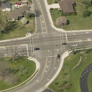 In late 2014, the Centers for Disease Control (CDC), in partnership with the American Planning Association (APA) and the American Public Health Association (APHA), initiated a nationwide effort to increase opportunities for physical activity. As a lack of physical activity is a primary indicator of chronic disease, these organizations recognized the strong link between community design and public health. Community design plays a vital role in creating opportunities for physical activity, through the incorporation of sidewalks, bicycle infrastructure, and other design elements that not only allow, but promote, movement. Thus, these partnering organizations facilitated the establishment of a grant program called the Plan4Health Initiative. This initiative encouraged communities to form coalitions and implement strategies within the built environment that encourage active living.
The coalition team in Columbus, led by Healthy Communities and the City of Columbus Planning Department, was one of only 18 communities nationwide selected to implement a Plan4Health project. The local project included the following 3 strategies: (1) the improvement of bicycle and pedestrian infrastructure in the neighborhood between Noblitt, Donner, and Lincoln Parks, including the analysis and redesign of crossing treatments at several key intersections, (2) a review of the policies and procedures, in partnership with the Indiana Department of Transportation (INDOT), for the design of safe and convenient bicycle and pedestrian crossings at state highway intersections, and (3) the launch of a broad public awareness campaign, called “Go Healthy, Columbus,” which emphasizes the importance of designing and building our community in a way that makes an active lifestyle the easy choice.
The following document describes the outcome of the infrastructure-related components of the Plan4Health project, listed as Strategies 1 and 2 above.
City of Columbus Intersection Study: A Plan4Health Initiative (PDF)
Development & Access Study Between Goeller Boulevard & State Road 46
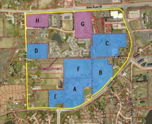 Over the past few years, there has been new development on the west side of Columbus off of Goeller Boulevard, south of State Road 46. During the review of these new developments, the City of Columbus Plan Commission had expressed concerns about additional traffic in the area and the preferred scenarios for access for these developing properties. In response to these concerns, the Planning Department has prepared a study focused on an area bound by State Road 46, Goeller Boulevard, and County Road 350 West. This study highlights the existing conditions, potential properties that could develop in the future, and access constraints for the area. It will also illustrate access options and alternatives for properties in the focus area that have potential to develop in the future.
Development & Access Study (PDF)
Golden Casting Foundry Site Redevelopment Options Study
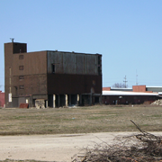 The Golden Casting Foundry Site Redevelopment Options Study was initiated in 2006. At that time, all research in the document was completed. In September 2012, the document was reopened, updated as needed for the purpose of further promoting and supporting the redevelopment of this area, and adopted by City Council. The study examines the former Golden Casting Foundry site and vicinity, its physical conditions and area demographics, the opportunities that exist, and the recommended options for redevelopment. The study is intended to identify general concepts for the future redevelopment of the foundry site. The study does not include specific redevelopment proposals, timelines, or other specific details.
The Golden Casting Foundry Site Redevelopment Options Study (PDF)