Our River…
Our Riverfront
Resources
Riverfront Master Plan
On January 22nd, 2018, Hitchcock Design Group presented the Columbus Redevelopment Commission with the final concept for the Columbus Riverfront project that includes several overlooks of the East Fork of the White River, connections to the People Trail system, in-river recreation opportunities, and many other captivating amenities.

Project Summary
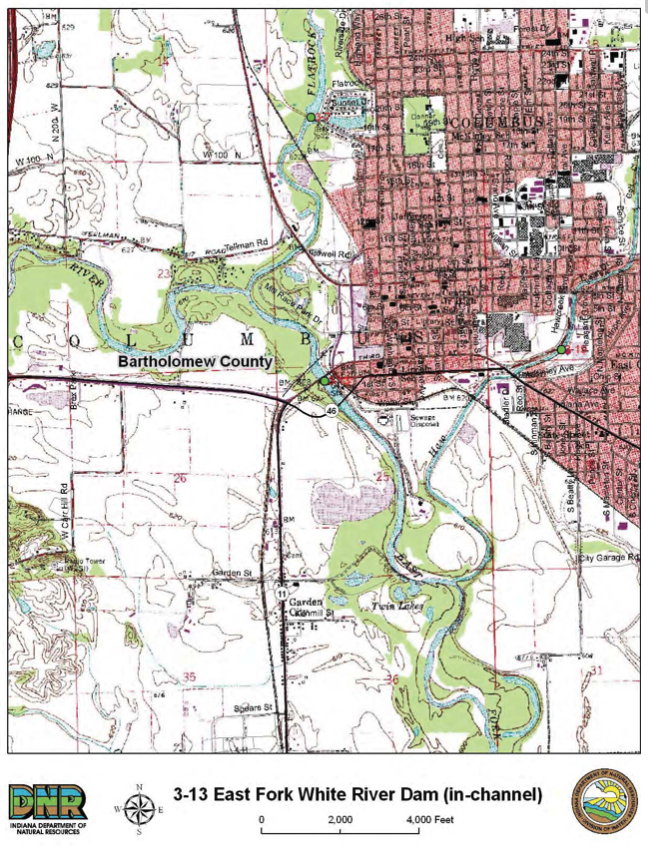
The Columbus Redevelopment Commission is leading an initiative to improve the appearance, recreational function, environmental quality, and economic benefit of the East Fork of the White River between the 2nd and 3rd Street bridges (see project map).
On behalf of the city, the Redevelopment Commission engaged a team of planning, design, engineering, and market economic professionals led by Hitchcock Design Group to create a compelling riverfront concept that improves access to and along the river, and creates dynamic public places consistent with the city’s rich cultural history.
As an integral part of the project, the team considered modifications of the low-head dam to improve river water quality, safety, and navigation. The concept was finished in September and introduced to the community during a series of public workshops and meetings.


Opportunity Analysis
The consultant team and Redevelopment Commission followed a three phase process starting with the Opportunity Analysis, which identified issues and the most promising strategies to meet the city’s aesthetic, recreational, environmental, and economic objectives for redeveloping the riverfront.
These strategies were based on the physical and natural characteristics of the project site, the available cultural and financial resources, and the interests of the public and related stakeholders.
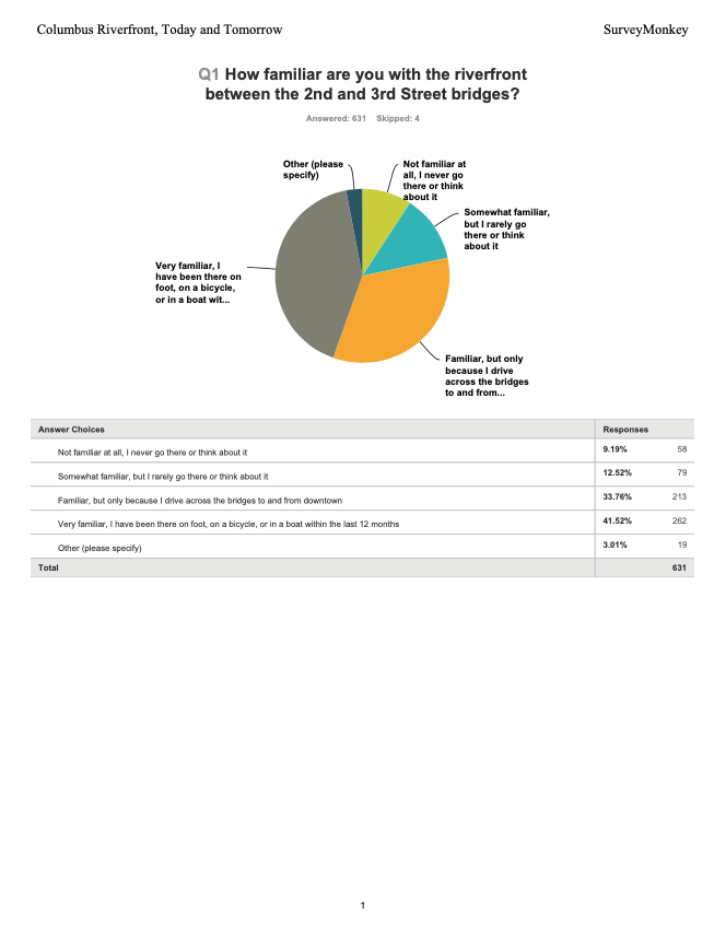
This phase concluded with an Opportunity Analysis Report that included the results of a web-based survey, key stakeholder interviews, a market analysis, and a public workshop.
Alternative Riverfront Concepts
Next, during the Alternative Riverfront Concepts phase, the consultant team came to a consensus on an overall strategy, the most promising public sector improvements, and private sector redevelopment opportunities.
The consultant team then developed preliminary implementation recommendations while working closely with the Redevelopment Commission to refine the most promising concepts into a Preferred Riverfront Concept.
They also developed a Preliminary Implementation Memorandum that considered public policy, operational improvements, and capital improvement issues. This phase included a public open house to showcase the Preferred Riverfront Concept and receive public comment.


Riverfront Concept Plan
In the Riverfront Concept Plan phase, the consultant team documented and obtained approval of the finalized recommendations, including an Implementation Table outlining short term (3-5 year) capital and operational implementation projects, and Riverfront Improvement Guidelines detailing standards and best practices.
This information was published in a final Riverfront Concept Report summarizing the consultant team’s recommendations, which was then presented to the Columbus City Council, the Redevelopment Commission, and the public.
Funding Sources
In 2022, the Indiana Economic Development Corporation (IEDC) has determined that the Columbus Riverfront Project (“Our River….Our Riverfront”) is eligible for Regional Economic Acceleration and Development Initiative (READI) funding. Funding will be awarded in the amount of $600,000 to support Columbus’ vision to create an iconic riverfront experience that improves safety through connectivity and access, ecology, repair eroding banks, and expand usable greenspace and workforce development efforts.
The IEDC, in conjunction with Ernst and Young, have reviewed the Columbus Riverfront proposal prepared through collaboration between South Central Indiana Talent Region, SIHCDC, Columbus Redevelopment, The Columbus Park Foundation, ARa and additional contributors. We are very excited to receive READI state funding support, which will help drive the riverfront revitalization to come!
Additionally, the City recently received a $1.7 million grant from Next Level Trails to assist with constructing the project and is actively pursuing other grants as well.
| Date Received | Amount | Description | Type |
|---|---|---|---|
| 8/30/2022 | $5,600,000 | READI Funds | State Funding |
| 4/20/2022 | $1,727,000 | Next Level Trails | Grant Funding |
| 9/15/2020 | $5,000 | Duke Energy | Project Contribution |
| 2/12/2019 | $100,000 | The Columbus Park Foundation | Project Contribution |
| $7,432,000 | Total |
Project Information & Reports
Images


Opportunity Analysis Report
After months of research, analysis, and collaboration, Hitchcock Design Group has released the Opportunity Analysis Report. This report summarizes the findings of all research, workshops, and survey results, and analyzes those results to compile a list of possible opportunities for the Columbus Riverfront.
Low-head dams are ‘dam dangerous’

The issue of public safety around dams is important to anyone directly or indirectly involved in recreational activities in rivers or streams, especially as many Hoosiers are visiting areas for water recreation during the summer months.
Thousands of these “low head” dams are scattered across our country including several in and near Columbus, and while the name implies low hazard/low impact, nothing could be further from the truth. Low Head Dams have a quiet, inviting, picture postcard quality about them. But the water going over these dams can rise and erupt into a violent, death trap. These structures, generally less than 15 feet high, can create backflow currents and turbulence capable of producing disorientation, hypothermia, exhaustion, and brutal battering. The forces combine to create a practically inescapable circular trap for even the strongest, life jacket-clad swimmer.
Hoosiers and others planning water recreation in Indiana can access the Indiana DNR Interactive Low Head Dam Map. CLICK HERE to see where low-head dams are located throughout Indiana.
WFYI Indianapolis has created a documentary on the dangers of low head dams. The documentary was filmed in partnership with IDHS, IDNR, the Indiana Silver Jackets, Indiana University Purdue University Indianapolis, Manchester University and the U.S. Geological Survey, among others. CLICK HERE to watch the full documentary, or CLICK HERE to see a one minute preview.
CLICK HERE for tips on low-head dam safety!
Re-Imagining our Riverfront will create a safer river experience by removing the dangerous low-head dam located within the project site.
Columbus Cultural Resources
Geomorphic Assessment Report
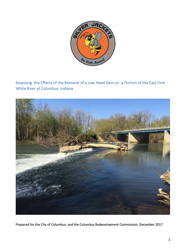
The Indiana Silver Jackets, a multi-agency hazard and mitigation response team, specializes in the removal of obsolete low head dams and the effects this has on the river. This report includes results from sediment mapping, hydraulic analysis, bathymetric mapping, and geomorphic assessment and analyzes the impact that dam removal would have on the Columbus Riverfront.
Bathymetric Survey
Officials were on the river Wednesday, March 29, 2017, conducting a BATHYMETRIC survey. This unique survey studies the bottom of the East Fork of the White River in order to show exactly what the bottom of the river looks like – just like a topographic survey on land.
The information gathered from the river bottom study was used to create a HYDRAULIC MODEL of the river. The HYDRAULIC RIVER MODEL helped to show what will happen as we MODIFY THE DAM, add ripples to the river, or something else altogether. This model was necessary to determine the best solution for the in-river structures.


